 |
| Home |
 |
| Bryneglwys |
 |
| Picture Gallery |
 |
| Coal Mines Nr Me |
 |
| Lighting |
 |
| David Bick Archives |
 |
| Cornwall Archives |
| Coal mines near me |
|
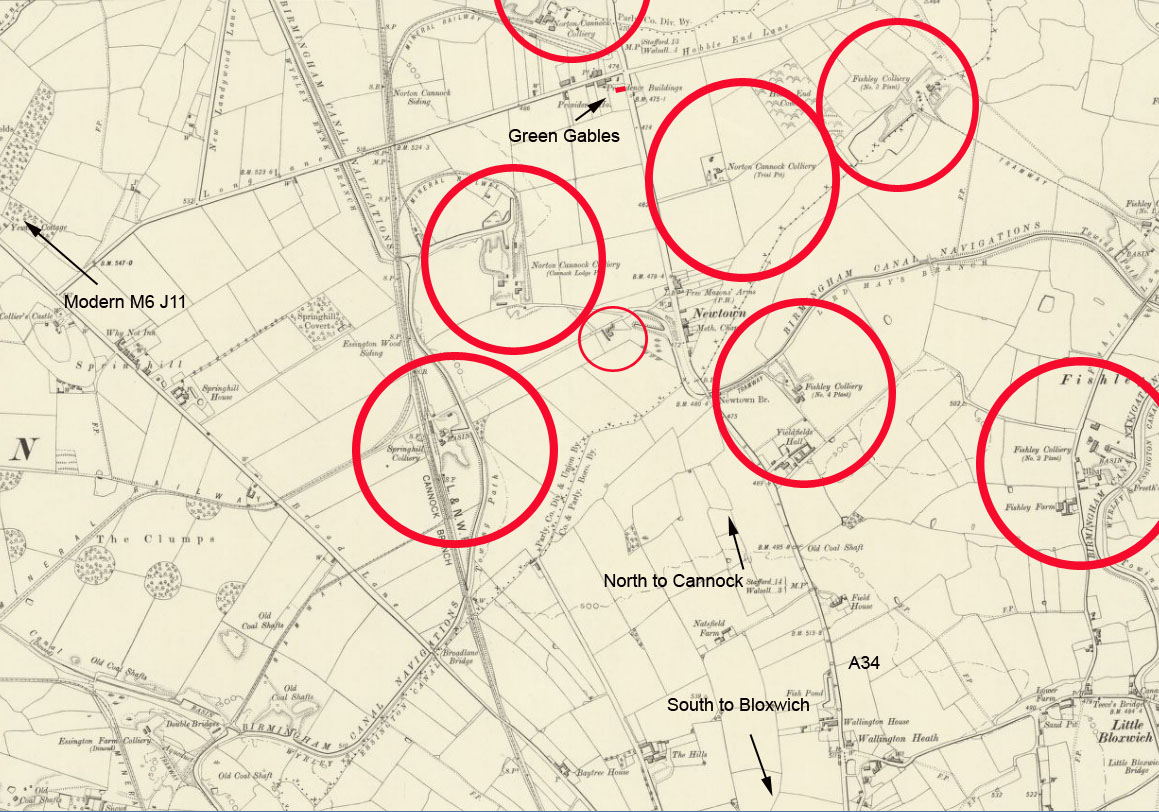
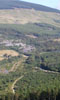
I live in the southern area of the Cannock Chase coalfield, but there are very few traces left of the many collieries that were once in the area. This is a brief summery of these sites, but first a bit of home history. I purchased my home in 1977 from a gentleman named Hawksworth. He was a coal merchant and haulage contractor, and his premises to the rear were purchased at the same time. The area is actually called "Newtown" and just to the north of my home was the Norton Cannock Colliery, this ceased about 1910, as did the Fishley and Springhill Collieries to the south. An early colliery was Cannock Lodge, this ceased much earlier and was taken over by Norton Cannock. Big problem was water, and when one pit closed own this would cause additional pumping requirements on adjacent pits, a knock on effect that lead to the closure of all the pits in the area. Below shows the area about 1900, of course my home wasn't there then.
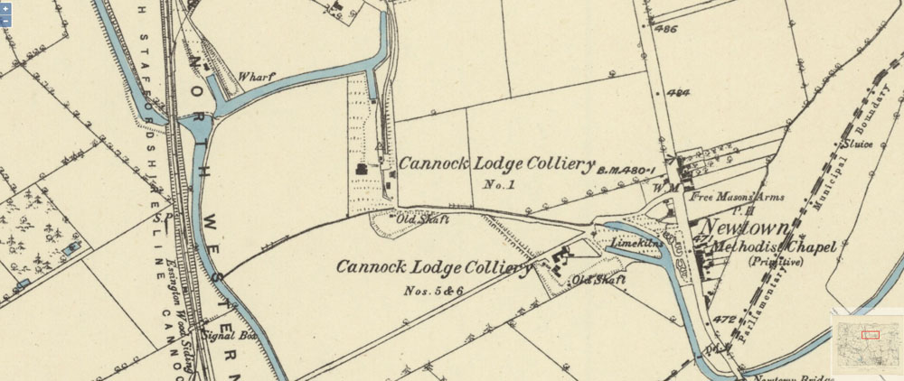
Cannock Lodge pit. The 1882 ordnance survey map shows two sites. The largest at SJ 988 044, described as the no 1 pit, and a smaller site to the south at SJ 991 042 described as 5 and 6 pits. As the map shows no other sites it is to be assumed that the intermediate numbered sites had fallen into disuse by that time.
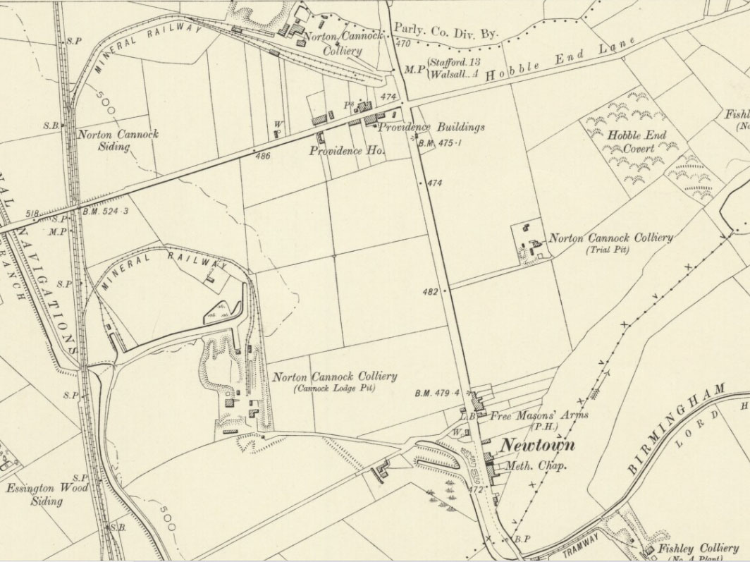
It was served by the western arm of the Wyrley and Essington canal and a branch of the LNWR railway. The no 1 pit (downcast) was 10feet diameter and sunk to a depth of 149 yards to “Deep Seam” with an inset at 136 yards to “Shallow Seam”. The headframe of timber was 36 feet high. No 2 (upcast) was same but 9 feet diameter. The no 3 pit 6 feet diameter was sunk to a depth of 36 yards to the “Four foot” seam. The mine had an underground steam powered haulage system by wire rope which ran for 800 yards underground, the rope passing down the shaft from surface winding by a two cylinder horizontal steam engine. Pumping was by a 27inch Bull Engine with a 7 foot stroke. In 1896 it was sold to Norton Cannock Colliery for £6500. Today nothing at all remains, just fields. The last vestiges were probably lost during extensive opencast working in the early 1990s. The smaller site to the south was served by the Lord Hays branch of the eastern arm of the Wyrley and Essington canal at the Newtown basins. The Lord Hays branch of the canal started at the Fishley no 1 road bridge and later served some of the Fishley collieries. It passed under the Newtown road bridge to end at the basins. The Lord Hays branch has now gone, as has the Newtown road bridge, probably in the early 1950s following an act of parliament relative to the filling in of old disused canals. I understand that the basins remained, at least in part, until the early 1990s when a massive opencast operation took out a lot of land west of the A34 at Newtown. The eastern arm of the canal is also gone. The Great Wyrley Junior Football club just off Long lane has a building that was originally the offices of the opencast. Today the site is fronted by The Lakes Retirement Home; the southern colliery site is now Newtown Farm. The lakes are two in number, the largest; the “Izaak Walston Fishiery” must have been caused by mining subsidence as it’s not shown on early maps. The smaller is not natural and is part of a land drainage system put in after the opencast operation. Norton Cannock The Norton Cannock Colliery Company operated three sites, with shafts being sunk to a depth of 190 yards (174 metres). The company employed 405 men underground and 113 surface workers over all sites, it closed in May 1910, as being unprofitable. The main and original site is at SJ 990 058, just north of Long Lane, Great Wyrley, and close to the A34 Stafford Road. It was served by a branch of the LNWR railway, and owned a Manning Wardle 0-6-0 saddle tank locomotive to haul the coal to the exchange sidings of the South Staffs Line Cannock Branch of the railway.
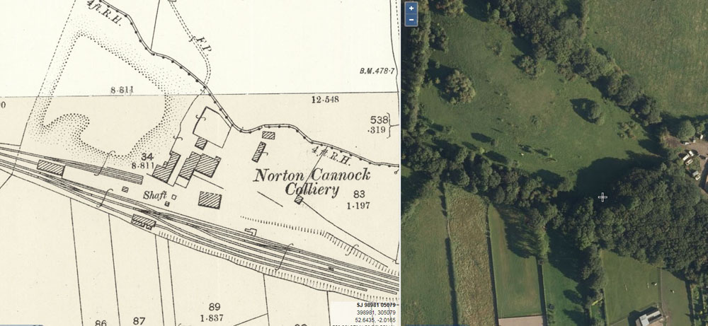
Today the site is overgrown woodland with the remains of obvious spoil heaps and a cutting which possibly represents the remains of a loading area shown on the 1900 map as the top branch of track. The frontage onto the A34 is a chalet and caravan park. In the picture below, + marks the position of the shaft which I believe has never been properly treated.
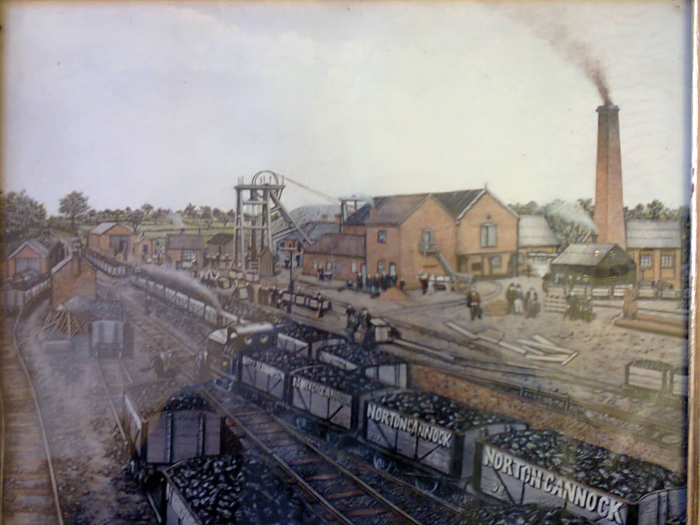
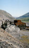
I (RF 2020) have memories of the site from early 1960s when I used to shoot rabbits there. My memory is of a significant mount, we called it “The Mount”. Today much reduced either by removal or ground settlement or subsidence. I have distinct memory of the railway siding still having rails in situ, also the railway building which i did not approach. We were taught in those days not to trespass on a railway. There was no sign of the shaft, I would definitely have remembered it if there was, I have vague memory of ruins of a small building on the approach, that is all. This leads me to believe that the shaft was filled in with the rubble of the buildings and never properly treated. We are fortunate to have sight of a painting of the colliery at work, date unknown. This was donated to the Cannock Chase railway Museum and is on their website.
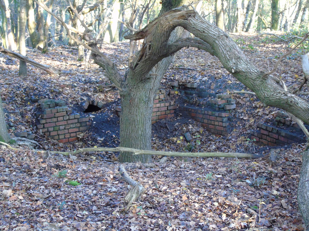
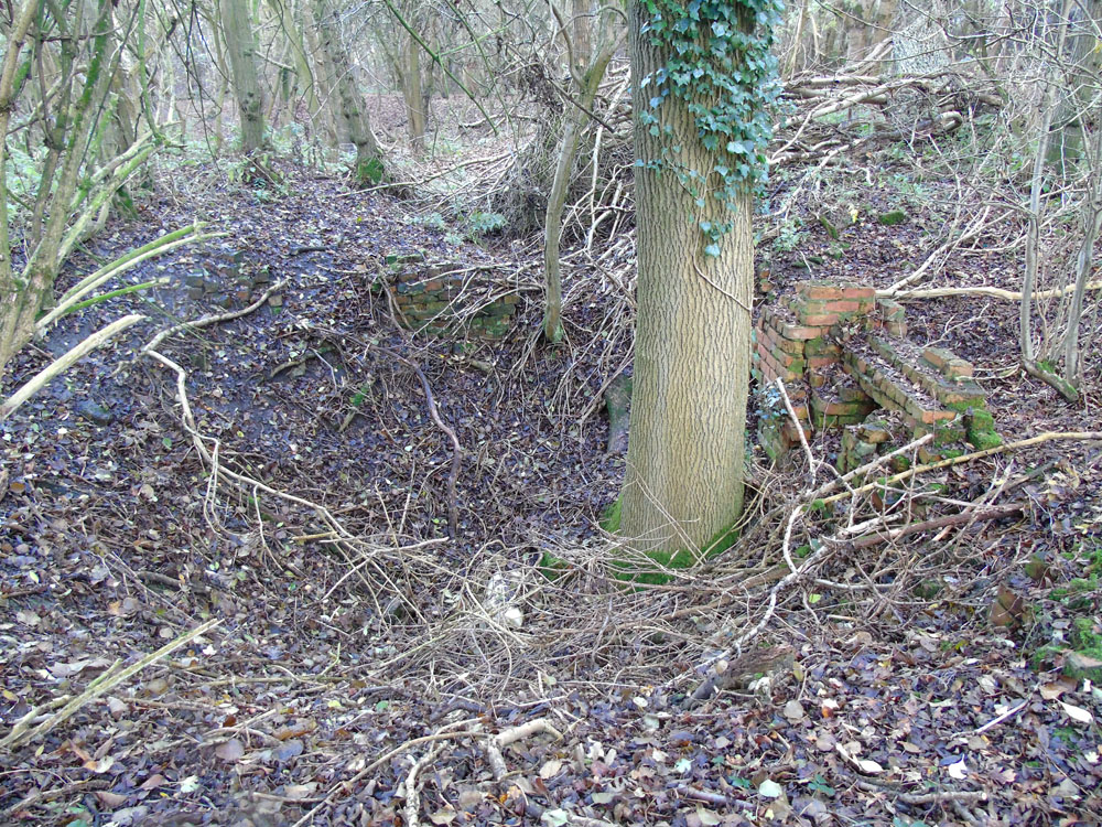
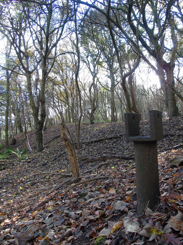
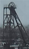
The second largest site is to the south at SJ988 044 was originally the main site of Cannock Lodge pit which Norton Cannock had taken over. (See more description under that site) This was also served by a branch of the railway and probably by the Lord Hays branch of the Essington and Great Wyrley canal. Today nothing at all remains, just fields. The last vestiges were probably lost during extensive opencast working in the early 1990s. The smallest site is at SJ994 047 and marked on the 1900 ordnance survey as a ”Trial Pit”. Today it’s the site of the Newtown Abattoir. Springhill Colliery Today nothing at all remains of that site, bar the badly overgrown canal basin which served it. Fishley Colliery No 3 plant. Well hidden in woodland to the south of Hobble End Lane it can be accessed by a public path. Although the other plants are further away, I will give a description of each one. Fishley colliery no1 was at SK 007 045 and records indicate working in 1865. However the 1883 OS described it as no's 1,2, and 3, the designations being changed as another three sites opened. It appears that originally the numbering related to shafts, but as the colliery expanded with other sites being opened, the numbering related to the sites. Today, all that remains is gruffy ground with obvious spoil within a clump of trees. The No 2 site at 006 038 was originally the no 4 and is close to Freeths Bridge on the main Wyrley and Essington canal. No 2 is a later designation when other sites were opened. Today the site is occupied by farm buildings. Its likely that the designations originally referred to shafts, but later to each plant. No 3 at SK 000 048 appears on the 1900 OS map under this designation, with two shafts, the easterly one at SK 00103 04948, and the westerly one at SK 00063 04900, and the plant connected to the original site (no 1) by a tramway. Today, it’s an interesting visit as it has quite a lot of features to be seen. There is the brick base of what was in all probability a chimney, with brick arched smoke flue on two sides, the western side extends to another square footing. Another square brick foundation to the east could be anything, but possibly the eastern shaft. An iron dolly stand at the back may have supported a power train, or maybe a pulley for a steel rope being part of a haulage system. This is all speculative, what is to be seen today does not sit particularly well with the Ordnance Survey. The spoil tips are vast and extensive and this site may well have been the prime working. No4 appears in 1900 immediately on the Lord Hays canal branch adjacent to Fishley no 3 bridge at SJ 997 041. Now Empty fields. Both the intermediate number 2 and the number 3 Fishley Bridges were demolished and the rubble together with that from the no 4 colliery used to fill in the canal. No 5 appears on the 1913 map at SJ992 036 and disused, as were all Fishley Colliery sites by then. Now it’s a patch of woodland in the middle of Turnberry housing estate. Not difficult to see why not built on. Shaft was probably behind the “One man and his Dog” pub. Further in, obvious spoil dumps can be found. The collieries went into liquidation in 1909 when all of the plant was sold by auction, an attempt to sell as a going concerned having failed. Plant included everything imaginable including 5 canal boats and an ambulance. Underground, all of the various sites connected and must have been a veritable maze of workings. There was an air shaft just east of the Stafford Road and slightly south of the Turnberry Road traffic lights. It’s recoded that a pit deputy went missing while underground and was never found, so his body is still down there. Below, base of chimney, No 3 pant.
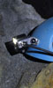
Below, possible site of the eastern shaft.
Below, dolly stand. May have been part of a haulage system. Extensive spoil tips in the background.
|